Rivers are one of nature’s most important features, providing water, food, and transportation for people and wildlife alike. They shape the land, support ecosystems, and influence the way humans live.
Some rivers are famous for their size, speed, or history, while others stand out for unique geographical features. One such river is the Limpopo, which flows across southern Africa and is known for a rare distinction: it crosses the Tropic of Capricorn twice. The Tropic of Capricorn is an imaginary line located about 23.5° south of the Equator, marking the southernmost point where the sun can be directly overhead. The Limpopo’s unusual path, combined with its seasonal flow, wildlife, and role in local communities, makes it a fascinating river worth exploring.
The Limpopo River: Africa’s S-shaped wonder that crosses the Tropic of Capricorn twice
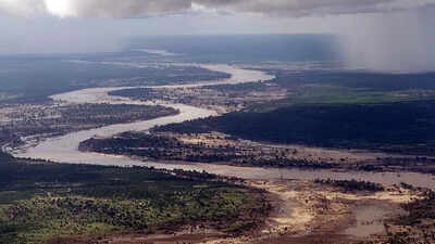
Rivers are the lifelines of our planet, shaping landscapes, ecosystems, and human civilisation. Among these, the Limpopo River stands out for its unusual geography. Flowing across southern Africa, it is one of the few rivers in the world that cuts the Tropic of Capricorn twice. The Tropic of Capricorn, an imaginary line located at approximately 23.5° south of the Equator, marks the southernmost point where the sun can be directly overhead during the December solstice.
The Limpopo’s unique course, winding through four countries, South Africa, Botswana, Zimbabwe, and Mozambique, creates a dramatic S-shaped path that fascinates geographers and nature enthusiasts alike.Originating as the Krokodil (Crocodile) River in South Africa’s Witwatersrand region, the Limpopo travels roughly 1,750 km (1,087 miles) before emptying into the Indian Ocean near Xai-Xai, Mozambique. Its river basin spans an impressive 415,000 km², supporting diverse ecosystems and human settlements along its banks.
This remarkable river’s journey across the Tropic of Capricorn twice makes it an extraordinary natural landmark in Africa.
A river that shapes borders, ecosystems, and human history
According to the Limpopo Watercourse Commission (LIMCOM), the official body that coordinates water-resource governance for the Limpopo Basin across Botswana, South Africa, Mozambique, and Zimbabwe, the Limpopo River is recognised as one of southern Africa’s major transboundary river systems. LIMCOM’s basin data highlights the river’s extensive geographical reach, diverse ecosystems, and vital role in supporting communities and wildlife along its path.For about 640 km of its length, it forms natural borders, separating South Africa from Botswana and Zimbabwe. These borders have historically influenced trade, settlement, and cultural exchange in the region. The river’s seasonal flow also defines its ecological character. During the summer rainy season, the Limpopo swells and floods, nourishing fertile floodplains and providing vital water for agriculture.
In contrast, the river slows and dries in winter, leaving pools that sustain wildlife in the region’s iconic reserves, including the Kruger National Park.Beyond its ecological and economic importance, the Limpopo River holds historical significance. The Mapungubwe area, located near the upper reaches of the river, was once part of a thriving trading kingdom around AD 1200. Archaeological evidence suggests that communities along the river engaged in trade, agriculture, and cultural exchange, making the Limpopo an artery of human civilisation long before modern borders were drawn.
Seasonal extremes and unique features of the Limpopo River
One of the most fascinating aspects of the Limpopo River is its seasonal behaviour. Its flow is highly variable: in dry years, the upper river may flow for just 40 days or less, while heavy rains can cause catastrophic floods, such as those triggered by Cyclone Eline in February 2000. The river carries significant sediment, giving it a silty, sluggish appearance for much of the year. Only near its mouth, after the confluence with the Olifants River, is it permanently navigable.The Limpopo also hosts an array of wildlife, making it a lifeline for the region’s biodiversity. Its waters and floodplains support fish, birds, and mammals, while the surrounding wetlands provide crucial habitat for endangered species. The river’s seasonal rhythms shape the lives of both humans and wildlife, demonstrating the interconnectedness of natural systems and human activity in southern Africa.The river’s basin is roughly the size of Sweden, underscoring its vast scale.
Its tributaries flow through some of Africa’s most iconic wildlife reserves, while ancient trade kingdoms along its banks highlight its role in shaping human history. Today, it remains the second-largest African river draining into the Indian Ocean, after the Zambezi, and continues to be a source of inspiration for explorers, scientists, and travellers alike.
From its dramatic S-curve to its seasonal extremes and historical importance, the Limpopo River is a remarkable natural wonder. Its rare distinction of crossing the Tropic of Capricorn twice makes it a captivating subject for geography enthusiasts and a vital lifeline for southern Africa’s people and wildlife.Also Read: Which countries have the most active volcanoes: Check the complete 2025 list of the world’s most volcanic countries

 5 hours ago
1


 English (US) ·