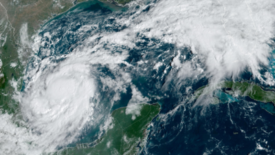
Florida
is potentially bracing for a third
hurricane
after
Milton
and
Helene
swept through and devastated the coastal US. The National Hurricane Center (NHC) is monitoring a developing weather system in the
Atlantic
. While the 2024 hurricane season is still ongoing, there are currently no active named storms. The next potential storm, likely to be named
Nadine
, has yet to form but is being monitored closely.
The NHC has identified an area of disturbed weather located several hundred miles west of the Cabo Verde Islands, with a 50 per cent chance of strengthening into a tropical depression within the next week.
Meteorologists have not released an official forecast for the potential storm but preliminary tracks suggest it could head towards southeast Florida after passing through Puerto Rico. As of Monday morning, the NHC reported that the system consists of a "well-defined area of low pressure" producing "disorganised showers and thunderstorms."
"This system is currently embedded in a dry environment, and development is unlikely over the next couple of days," the NHC said. However, it is expected to move westward towards warmer waters, creating more favourable conditions for storm development later in the week.
WFLA-TV chief meteorologist Jeff Berardelli informed Newsweek that while there are no immediate tropical threats, weather models indicate "lots of tropical waves and moisture festering for the next few weeks."
Additionally, AccuWeather meteorologists are tracking a gyre in the Western Caribbean that may develop into a stronger storm by the week's end. A gyre is a large system of rotating ocean currents that can influence local weather patterns by concentrating moisture and energy in the atmosphere. Jeff Berardelli noted that while "the models are lukewarm on development," warm ocean temperatures associated with this gyre could accelerate tropical storm formation.

 1 month ago
31


 English (US) ·