Stark U.N. emissions report on climate change
Climate scientists working at the European Union's Copernicus Climate Change Service have announced that 2024 is "virtually certain" to be the warmest year on record.
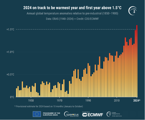
According to its ERA5 dataset, the agency said it was "virtually certain" that the annual temperature for 2024 will be more than 1.5 degrees Celsius above the pre-industrial level, and it will likely be more than 1.55 C above.
For decades, scientists have warned that average global temperatures should not get any higher than 1.5 C above pre-industrial times in order to prevent deadly weather conditions that could impact people worldwide.
The world has already warmed considerably and has seen the effects with back-to-back heat waves, droughts and unprecedented flooding and hurricane events. The way farmers are able to grow food has already started to shift, and with 1.5 to 2 degrees Celsius of warming, agricultural yields will decline and sea levels could rise up to 10 feet, researchers have found. Experts say the oceans will also be warmer, fueling more powerful hurricanes and threatening ecosystems that are fundamental for economies and help protect areas from inclement weather.
 Annual global surface air temperature anomalies (°C) relative to 1850–1900 from 1940 to 2024. The estimate for 2024 is provisional and based on data from January to October.
Copernicus Climate Change Service /ECMWF
"This marks a new milestone in global temperature records and should serve as a catalyst to raise ambition for the upcoming Climate Change Conference, COP29," said Samantha Burgess, deputy director of the Copernicus Climate Change Service, in a statement.
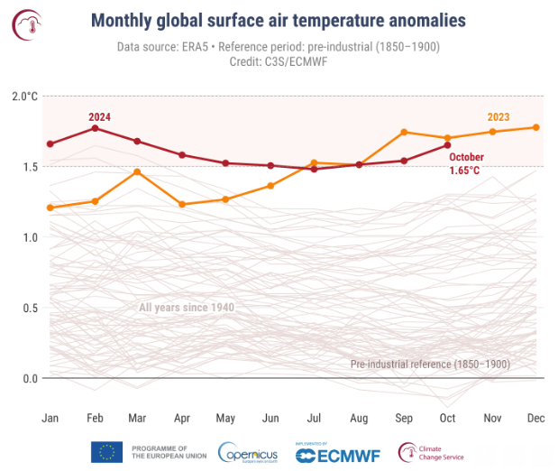
The Copernicus Climate Change Service said the average global temperature anomaly for the first 10 months of 2024 (January to October) is 0.71 C above the 1991-2020 average, which is the highest on record for this period and 0.16 C warmer than the same period in 2023.
"The average temperature anomaly for the rest of 2024 would have to drop to almost zero for 2024 to not be the warmest year," the agency said.
The agency added that given that 2023 was 1.48°C above the pre-industrial level according to its ERA5 model, it was also likely that the annual temperature for 2024 will be more than 1.55°C above.
European temperatures were above average over almost all of the continent, Copernicus found. Outside Europe, temperatures were most above average over northern Canada, and well-above average over the central and western United States, northern Tibet, Japan and Australia.
 Monthly global surface air temperature anomalies in Celsius, relative to 1850–1900, from January 1940 to October 2024, plotted as time series for each year. 2024 is shown with a thick red line, 2023 with a thick orange line, and all other years with thin grey lines.
Copernicus Climate Change Service /ECMWF
The agency also said Arctic sea ice reached its fourth lowest monthly extent for October, at 19% below average. Sea ice extent is a measure of the surface area of the ocean which is covered by ice.
Sea ice concentration anomalies were well below average in all peripheral seas of the Arctic Ocean, particularly in the Barents Sea, Canadian Archipelago, and north of Svalbard, the agency said.
Antarctic sea ice extent was 8% below average in October, which was the second-lowest such average behind only October 2023, when it was 11% below average, Copernicus said. Those numbers continued "a series of large negative anomalies observed throughout 2023 and 2024."
The Copernicus Climate Change Service, which is funded by the EU, routinely publishes monthly climate bulletins reporting on changes observed in global surface air and sea temperatures, sea ice cover and hydrological variables. All the reported findings are based on computer-generated analyses and the ERA5 dataset, which uses billions of measurements from satellites, ships, aircraft and weather stations around the world.
In a report published last month, the United Nations warned that the world is now in "climate crunch time" as greenhouse gases — which trap heat in the atmosphere that warms global temperatures and fuels more extreme weather events — have hit "unprecedented levels."
"The numbers paint a clear picture," the U.N. said. "To keep emissions below the critical 1.5-degree target set in Paris in 2015, countries must cut emissions by 42 percent overall by 2030 and achieve a 57 percent reduction by 2035."
Elias Lopez is a senior editor at CBSNews.com. He covers a variety of news events and works with reporters on developing stories in politics, international news and more.


 English (US) ·